


Dynamic river networks
You’ve heard the phrase “as old as the hills”? The hills really are old, but that doesn’t mean they aren’t changing! In many landscapes, the hills are moving – not just up and down, but sideways. The same is true of rivers and the watersheds that surround them: watersheds are dynamic features that grow, shrink, and occasionally merge or split. Even though that’s happening very slowly, we’ve developed techniques for measuring it.
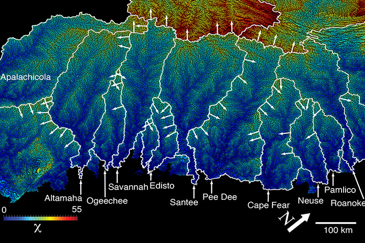
Taylor Perron and Prof. Leigh Royden proposed a rescaled distance coordinate for bedrock rivers, denoted by the Greek letter Chi, that can reveal whether a river is eroding at the same rate all along its profile. In collaboration with Sean Willett (ETH Zürich), Scott McCoy and Perron then showed how maps of Chi throughout a landscape can reveal which drainage basins are growing, which ones are shrinking, and which ones have experienced a sudden increase in size due to river capture – the abrupt rerouting of a river.
- Perron, J.T. and L. Royden (2013), An integral approach to bedrock river profile analysis. Earth Surface Processes and Landforms, 38, 570-576, http://doi.org/10.1002/esp.3302.
- Royden, L. and J.T. Perron (2013), Solutions of the stream power equation and application to the evolution of river longitudinal profiles. J. Geophys. Res., 118, 497–518, http://doi.org/10.1002/jgrf.20031.
- Willett, S.D., S.W. McCoy, J.T. Perron, L. Goren and C.Y. Chen (2014), Dynamic reorganization of river basins. Science, 343 (6175), 1248765, http://doi.org/10.1126/science.1248765.
The very slow motion of drainage divides, punctuated by the occasional river capture, is very hard to measure directly, so we usually don’t know how fast the divides are moving, when a given river capture occurred, or how each river capture comes about. Maya Stokes and Sam Goldberg used the case study of the Rio Casiquiare, an ongoing river capture in the northern Amazon, to study how large rivers exchange drainage area. Stokes is currently collaborating with Isaac Larsen (UMass Amherst), Goldberg, McCoy, and Philip Prince to measure rates of drainage divide migration and ages of river captures along the Blue Ridge Escarpment in the southern Appalachian Mountains.
- Stokes, M.F., S.L. Goldberg and J.T. Perron (2018). Ongoing river capture in the Amazon. Geophys. Res. Lett., 45, 5545-5552, http://doi.org/10.1029/2018GL078129.65.
- Stokes, M.F., I.J. Larsen, S.L. Goldberg, S. McCoy, P. Prince, and J.T. Perron (2023). The erosional signature of divide motion along the Blue Ridge Escarpment. Journal of Geophysical Research – Earth Surface, 128, e2022JF006757, https://doi.org/10.1029/2022JF006757
This work on dynamic river networks builds on an earlier study by Perron, former students Paul Richardson and Mathieu Lapotre, and former postdoctoral researcher Ken Ferrier that identified the mechanisms that give river networks their characteristic branching shape.
- Perron, J.T., P.W. Richardson, K.L. Ferrier, and M. Lapôtre (2012), The root of branching river networks. Nature, 492, 100–103, http://doi.org/10.1038/nature11672.
